Abstract base class for all geometry classes. More...
#include <ogr_geometry.h>
Public Member Functions | |
| OGRGeometry (const OGRGeometry &other) | |
| Copy constructor. | |
| OGRGeometry (OGRGeometry &&other) | |
| Move constructor. | |
| OGRGeometry & | operator= (const OGRGeometry &other) |
| Assignment operator. | |
| OGRGeometry & | operator= (OGRGeometry &&other) |
| Move assignment operator. | |
| bool | operator== (const OGRGeometry &other) const |
| Returns if two geometries are equal. | |
| bool | operator!= (const OGRGeometry &other) const |
| Returns if two geometries are different. | |
| virtual int | getDimension () const =0 |
| Get the dimension of this object. | |
| virtual int | getCoordinateDimension () const |
| Get the dimension of the coordinates in this object. | |
| int | CoordinateDimension () const |
| Get the dimension of the coordinates in this object. | |
| virtual OGRBoolean | IsEmpty () const =0 |
| Returns TRUE (non-zero) if the object has no points. | |
| virtual OGRBoolean | IsValid (std::string *posReason=nullptr) const |
| Test if the geometry is valid. | |
| virtual OGRGeometry * | MakeValid (CSLConstList papszOptions=nullptr) const |
| Attempts to make an invalid geometry valid without losing vertices. | |
| virtual OGRGeometry * | Normalize () const |
| Attempts to bring geometry into normalized/canonical form. | |
| virtual OGRBoolean | IsSimple () const |
| Test if the geometry is simple. | |
| OGRBoolean | Is3D () const |
| OGRBoolean | IsMeasured () const |
| virtual OGRBoolean | IsRing () const |
| Test if the geometry is a ring. | |
| virtual void | empty ()=0 |
| Clear geometry information. | |
| virtual OGRGeometry * | clone () const =0 |
| Make a copy of this object. | |
| virtual void | getEnvelope (OGREnvelope *psEnvelope) const =0 |
| Computes and returns the bounding envelope for this geometry in the passed psEnvelope structure. | |
| virtual void | getEnvelope (OGREnvelope3D *psEnvelope) const =0 |
| Computes and returns the bounding envelope (3D) for this geometry in the passed psEnvelope structure. | |
| virtual size_t | WkbSize () const =0 |
| Returns size of related binary representation. | |
| OGRErr | importFromWkb (const GByte *, size_t=static_cast< size_t >(-1), OGRwkbVariant=wkbVariantOldOgc) |
| Assign geometry from well known binary data. | |
| virtual OGRErr | importFromWkb (const unsigned char *, size_t, OGRwkbVariant, size_t &nBytesConsumedOut)=0 |
| Assign geometry from well known binary data. | |
| OGRErr | exportToWkb (OGRwkbByteOrder, unsigned char *, OGRwkbVariant=wkbVariantOldOgc) const |
| Convert a geometry into well known binary format. | |
| virtual OGRErr | exportToWkb (unsigned char *, const OGRwkbExportOptions *=nullptr) const =0 |
| Convert a geometry into well known binary format. | |
| virtual OGRErr | importFromWkt (const char **ppszInput)=0 |
| Assign geometry from well known text data. | |
| OGRErr | importFromWkt (char **ppszInput) |
| Deprecated. | |
| OGRErr | exportToWkt (char **ppszDstText, OGRwkbVariant=wkbVariantOldOgc) const |
| Convert a geometry into well known text format. | |
| virtual std::string | exportToWkt (const OGRWktOptions &opts=OGRWktOptions(), OGRErr *err=nullptr) const =0 |
| Export a WKT geometry. | |
| virtual OGRwkbGeometryType | getGeometryType () const =0 |
| Fetch geometry type. | |
| OGRwkbGeometryType | getIsoGeometryType () const |
| Get the geometry type that conforms with ISO SQL/MM Part3. | |
| virtual const char * | getGeometryName () const =0 |
| Fetch WKT name for geometry type. | |
| void | dumpReadable (FILE *, const char *=nullptr, CSLConstList papszOptions=nullptr) const |
| Dump geometry in well known text format to indicated output file. | |
| std::string | dumpReadable (const char *=nullptr, CSLConstList papszOptions=nullptr) const |
| Dump geometry in well known text format to indicated output file. | |
| virtual void | flattenTo2D ()=0 |
| Convert geometry to strictly 2D. | |
| virtual char * | exportToGML (const char *const *papszOptions=nullptr) const |
| Convert a geometry into GML format. | |
| virtual char * | exportToKML () const |
| Convert a geometry into KML format. | |
| virtual char * | exportToJson (CSLConstList papszOptions=nullptr) const |
| Convert a geometry into GeoJSON format. | |
| virtual void | accept (IOGRGeometryVisitor *visitor)=0 |
| Accept a visitor. | |
| virtual void | accept (IOGRConstGeometryVisitor *visitor) const =0 |
| Accept a visitor. | |
| GEOSGeom | exportToGEOS (GEOSContextHandle_t hGEOSCtxt, bool bRemoveEmptyParts=false, bool bAddPointsIfNeeded=false) const |
| Returns a GEOSGeom object corresponding to the geometry. | |
| virtual OGRBoolean | hasCurveGeometry (int bLookForNonLinear=FALSE) const |
| Returns if this geometry is or has curve geometry. | |
| virtual OGRGeometry * | getCurveGeometry (const char *const *papszOptions=nullptr) const |
| Return curve version of this geometry. | |
| virtual OGRGeometry * | getLinearGeometry (double dfMaxAngleStepSizeDegrees=0, const char *const *papszOptions=nullptr) const |
| Return, possibly approximate, non-curve version of this geometry. | |
| void | roundCoordinates (const OGRGeomCoordinatePrecision &sPrecision) |
| Round coordinates of the geometry to the specified precision. | |
| void | roundCoordinatesIEEE754 (const OGRGeomCoordinateBinaryPrecision &options) |
| Round coordinates of a geometry, exploiting characteristics of the IEEE-754 double-precision binary representation. | |
| virtual void | closeRings () |
| Force rings to be closed. | |
| virtual bool | setCoordinateDimension (int nDimension) |
| Set the coordinate dimension. | |
| virtual bool | set3D (OGRBoolean bIs3D) |
| Add or remove the Z coordinate dimension. | |
| virtual bool | setMeasured (OGRBoolean bIsMeasured) |
| Add or remove the M coordinate dimension. | |
| virtual void | assignSpatialReference (const OGRSpatialReference *poSR) |
| Assign spatial reference to this object. | |
| const OGRSpatialReference * | getSpatialReference (void) const |
| Returns spatial reference system for object. | |
| virtual OGRErr | transform (OGRCoordinateTransformation *poCT)=0 |
| Apply arbitrary coordinate transformation to geometry. | |
| OGRErr | transformTo (const OGRSpatialReference *poSR) |
| Transform geometry to new spatial reference system. | |
| virtual bool | segmentize (double dfMaxLength) |
| Modify the geometry such it has no segment longer then the given distance. | |
| virtual OGRBoolean | Intersects (const OGRGeometry *) const |
| Do these features intersect? | |
| virtual OGRBoolean | Equals (const OGRGeometry *) const =0 |
| Returns TRUE if two geometries are equivalent. | |
| OGRBoolean | Disjoint (const OGRGeometry *) const |
| Test for disjointness. | |
| OGRBoolean | Touches (const OGRGeometry *) const |
| Test for touching. | |
| OGRBoolean | Crosses (const OGRGeometry *) const |
| Test for crossing. | |
| virtual OGRBoolean | Within (const OGRGeometry *) const |
| Test for containment. | |
| virtual OGRBoolean | Contains (const OGRGeometry *) const |
| Test for containment. | |
| OGRBoolean | Overlaps (const OGRGeometry *) const |
| Test for overlap. | |
| OGRGeometry * | Boundary () const |
| Compute boundary. | |
| double | Distance (const OGRGeometry *) const |
| Compute distance between two geometries. | |
| OGRGeometry * | ConvexHull () const |
| Compute convex hull. | |
| OGRGeometry * | ConcaveHull (double dfRatio, bool bAllowHoles) const |
| Compute the concave hull of a geometry. | |
| OGRGeometry * | ConcaveHullOfPolygons (double dfLengthRatio, bool bIsTight, bool bAllowHoles) const |
| Compute the concave hull of a set of polygons, respecting the polygons as constraints. | |
| OGRGeometry * | Buffer (double dfDist, int nQuadSegs=30) const |
| Compute buffer of geometry. | |
| OGRGeometry * | BufferEx (double dfDist, CSLConstList papszOptions) const |
| Compute buffer of geometry. | |
| OGRGeometry * | Intersection (const OGRGeometry *) const |
| Compute intersection. | |
| OGRGeometry * | Union (const OGRGeometry *) const |
| Compute union. | |
| OGRGeometry * | UnionCascaded () const |
| Compute union using cascading. | |
| OGRGeometry * | UnaryUnion () const |
| Returns the union of all components of a single geometry. | |
| OGRGeometry * | Difference (const OGRGeometry *) const |
| Compute difference. | |
| OGRGeometry * | SymDifference (const OGRGeometry *) const |
| Compute symmetric difference. | |
| OGRErr | Centroid (OGRPoint *poPoint) const |
| Compute the geometry centroid. | |
| OGRGeometry * | Simplify (double dTolerance) const |
| Simplify the geometry. | |
| OGRGeometry * | SimplifyPreserveTopology (double dTolerance) const |
| Simplify the geometry while preserving topology. | |
| OGRGeometry * | DelaunayTriangulation (double dfTolerance, int bOnlyEdges) const |
| Return a Delaunay triangulation of the vertices of the geometry. | |
| OGRGeometry * | ConstrainedDelaunayTriangulation () const |
| Return a constrained Delaunay triangulation of the vertices of the given polygon(s). | |
| OGRGeometry * | Polygonize () const |
| Polygonizes a set of sparse edges. | |
| OGRGeometry * | BuildArea () const |
| Polygonize a linework assuming inner polygons are holes. | |
| double | Distance3D (const OGRGeometry *poOtherGeom) const |
| Returns the 3D distance between two geometries. | |
| OGRGeometry * | SetPrecision (double dfGridSize, int nFlags) const |
| Set the geometry's precision, rounding all its coordinates to the precision grid, and making sure the geometry is still valid. | |
| virtual bool | hasEmptyParts () const |
| Returns whether a geometry has empty parts/rings. | |
| virtual void | removeEmptyParts () |
| Remove empty parts/rings from this geometry. | |
| virtual void | swapXY () |
| Swap x and y coordinates. | |
| bool | IsRectangle () const |
| Returns whether the geometry is a polygon with 4 corners forming a rectangle. | |
| OGRPoint * | toPoint () |
| Down-cast to OGRPoint*. | |
| const OGRPoint * | toPoint () const |
| Down-cast to OGRPoint*. | |
| OGRCurve * | toCurve () |
| Down-cast to OGRCurve*. | |
| const OGRCurve * | toCurve () const |
| Down-cast to OGRCurve*. | |
| OGRSimpleCurve * | toSimpleCurve () |
| Down-cast to OGRSimpleCurve*. | |
| const OGRSimpleCurve * | toSimpleCurve () const |
| Down-cast to OGRSimpleCurve*. | |
| OGRLineString * | toLineString () |
| Down-cast to OGRLineString*. | |
| const OGRLineString * | toLineString () const |
| Down-cast to OGRLineString*. | |
| OGRLinearRing * | toLinearRing () |
| Down-cast to OGRLinearRing*. | |
| const OGRLinearRing * | toLinearRing () const |
| Down-cast to OGRLinearRing*. | |
| OGRCircularString * | toCircularString () |
| Down-cast to OGRCircularString*. | |
| const OGRCircularString * | toCircularString () const |
| Down-cast to OGRCircularString*. | |
| OGRCompoundCurve * | toCompoundCurve () |
| Down-cast to OGRCompoundCurve*. | |
| const OGRCompoundCurve * | toCompoundCurve () const |
| Down-cast to OGRCompoundCurve*. | |
| OGRSurface * | toSurface () |
| Down-cast to OGRSurface*. | |
| const OGRSurface * | toSurface () const |
| Down-cast to OGRSurface*. | |
| OGRPolygon * | toPolygon () |
| Down-cast to OGRPolygon*. | |
| const OGRPolygon * | toPolygon () const |
| Down-cast to OGRPolygon*. | |
| OGRTriangle * | toTriangle () |
| Down-cast to OGRTriangle*. | |
| const OGRTriangle * | toTriangle () const |
| Down-cast to OGRTriangle*. | |
| OGRCurvePolygon * | toCurvePolygon () |
| Down-cast to OGRCurvePolygon*. | |
| const OGRCurvePolygon * | toCurvePolygon () const |
| Down-cast to OGRCurvePolygon*. | |
| OGRGeometryCollection * | toGeometryCollection () |
| Down-cast to OGRGeometryCollection*. | |
| const OGRGeometryCollection * | toGeometryCollection () const |
| Down-cast to OGRGeometryCollection*. | |
| OGRMultiPoint * | toMultiPoint () |
| Down-cast to OGRMultiPoint*. | |
| const OGRMultiPoint * | toMultiPoint () const |
| Down-cast to OGRMultiPoint*. | |
| OGRMultiLineString * | toMultiLineString () |
| Down-cast to OGRMultiLineString*. | |
| const OGRMultiLineString * | toMultiLineString () const |
| Down-cast to OGRMultiLineString*. | |
| OGRMultiPolygon * | toMultiPolygon () |
| Down-cast to OGRMultiPolygon*. | |
| const OGRMultiPolygon * | toMultiPolygon () const |
| Down-cast to OGRMultiPolygon*. | |
| OGRMultiCurve * | toMultiCurve () |
| Down-cast to OGRMultiCurve*. | |
| const OGRMultiCurve * | toMultiCurve () const |
| Down-cast to OGRMultiCurve*. | |
| OGRMultiSurface * | toMultiSurface () |
| Down-cast to OGRMultiSurface*. | |
| const OGRMultiSurface * | toMultiSurface () const |
| Down-cast to OGRMultiSurface*. | |
| OGRPolyhedralSurface * | toPolyhedralSurface () |
| Down-cast to OGRPolyhedralSurface*. | |
| const OGRPolyhedralSurface * | toPolyhedralSurface () const |
| Down-cast to OGRPolyhedralSurface*. | |
| OGRTriangulatedSurface * | toTriangulatedSurface () |
| Down-cast to OGRTriangulatedSurface*. | |
| const OGRTriangulatedSurface * | toTriangulatedSurface () const |
| Down-cast to OGRTriangulatedSurface*. | |
Static Public Member Functions | |
| static GEOSContextHandle_t | createGEOSContext () |
| Create a new GEOS context. | |
| static void | freeGEOSContext (GEOSContextHandle_t hGEOSCtxt) |
| Destroy a GEOS context. | |
| static OGRGeometryH | ToHandle (OGRGeometry *poGeom) |
| Convert a OGRGeometry* to a OGRGeometryH. | |
| static OGRGeometry * | FromHandle (OGRGeometryH hGeom) |
| Convert a OGRGeometryH to a OGRGeometry*. | |
Detailed Description
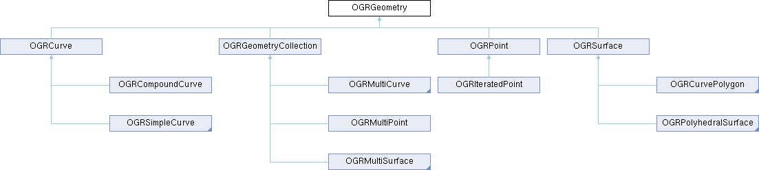
Abstract base class for all geometry classes.
Some spatial analysis methods require that OGR is built on the GEOS library to work properly. The precise meaning of methods that describe spatial relationships between geometries is described in the SFCOM, or other simple features interface specifications, like "OpenGIS® Implementation Specification for Geographic information - Simple feature access - Part 1: Common architecture": OGC 06-103r4
The hierarchy of classes has been extended with (working draft) ISO SQL/MM Part 3 (ISO/IEC 13249-3) curve geometries : CIRCULARSTRING (OGRCircularString), COMPOUNDCURVE (OGRCompoundCurve), CURVEPOLYGON (OGRCurvePolygon), MULTICURVE (OGRMultiCurve) and MULTISURFACE (OGRMultiSurface).
Constructor & Destructor Documentation
◆ OGRGeometry()
| OGRGeometry::OGRGeometry | ( | OGRGeometry && | other | ) |
Move constructor.
- Since
- GDAL 3.11
Member Function Documentation
◆ accept() [1/2]
|
pure virtual |
Accept a visitor.
Implemented in OGRPoint, OGRLineString, OGRLinearRing, OGRCircularString, OGRCompoundCurve, OGRCurvePolygon, OGRPolygon, OGRTriangle, OGRGeometryCollection, OGRMultiSurface, OGRMultiPolygon, OGRPolyhedralSurface, OGRTriangulatedSurface, OGRMultiPoint, OGRMultiCurve, and OGRMultiLineString.
◆ accept() [2/2]
|
pure virtual |
Accept a visitor.
Implemented in OGRPoint, OGRLineString, OGRLinearRing, OGRCircularString, OGRCompoundCurve, OGRCurvePolygon, OGRPolygon, OGRTriangle, OGRGeometryCollection, OGRMultiSurface, OGRMultiPolygon, OGRPolyhedralSurface, OGRTriangulatedSurface, OGRMultiPoint, OGRMultiCurve, and OGRMultiLineString.
◆ assignSpatialReference()
|
virtual |
Assign spatial reference to this object.
Any existing spatial reference is replaced, but under no circumstances does this result in the object being reprojected. It is just changing the interpretation of the existing geometry. Note that assigning a spatial reference increments the reference count on the OGRSpatialReference, but does not copy it.
This will also assign the spatial reference to potential sub-geometries of the geometry (OGRGeometryCollection, OGRCurvePolygon/OGRPolygon, OGRCompoundCurve, OGRPolyhedralSurface and their derived classes).
This is similar to the SFCOM IGeometry::put_SpatialReference() method.
This method is the same as the C function OGR_G_AssignSpatialReference().
- Parameters
-
poSR new spatial reference system to apply.
Reimplemented in OGRCompoundCurve, OGRCurvePolygon, OGRGeometryCollection, and OGRPolyhedralSurface.
◆ Boundary()
| OGRGeometry * OGRGeometry::Boundary | ( | ) | const |
Compute boundary.
A new geometry object is created and returned containing the boundary of the geometry on which the method is invoked.
This method is the same as the C function OGR_G_Boundary().
This method is built on the GEOS library, check it for the definition of the geometry operation. If OGR is built without the GEOS library, this method will always fail, issuing a CPLE_NotSupported error.
- Returns
- a new geometry to be freed by the caller, or NULL if an error occurs.
◆ Buffer()
| OGRGeometry * OGRGeometry::Buffer | ( | double | dfDist, |
| int | nQuadSegs = 30 |
||
| ) | const |
Compute buffer of geometry.
Builds a new geometry containing the buffer region around the geometry on which it is invoked. The buffer is a polygon containing the region within the buffer distance of the original geometry.
Some buffer sections are properly described as curves, but are converted to approximate polygons. The nQuadSegs parameter can be used to control how many segments should be used to define a 90 degree curve - a quadrant of a circle. A value of 30 is a reasonable default. Large values result in large numbers of vertices in the resulting buffer geometry while small numbers reduce the accuracy of the result.
This method is the same as the C function OGR_G_Buffer().
This method is built on the GEOS library, check it for the definition of the geometry operation. If OGR is built without the GEOS library, this method will always fail, issuing a CPLE_NotSupported error.
- Parameters
-
dfDist the buffer distance to be applied. Should be expressed into the same unit as the coordinates of the geometry. nQuadSegs the number of segments used to approximate a 90 degree (quadrant) of curvature.
- Returns
- a new geometry to be freed by the caller, or NULL if an error occurs.
◆ BufferEx()
| OGRGeometry * OGRGeometry::BufferEx | ( | double | dfDist, |
| CSLConstList | papszOptions | ||
| ) | const |
Compute buffer of geometry.
Builds a new geometry containing the buffer region around the geometry on which it is invoked. The buffer is a polygon containing the region within the buffer distance of the original geometry.
This function is built on the GEOS library, check it for the definition of the geometry operation. If OGR is built without the GEOS library, this function will always fail, issuing a CPLE_NotSupported error.
The following options are supported. See the GEOS library for more detailed descriptions.
- ENDCAP_STYLE=ROUND/FLAT/SQUARE
- JOIN_STYLE=ROUND/MITRE/BEVEL
- MITRE_LIMIT=double
- QUADRANT_SEGMENTS=int
- SINGLE_SIDED=YES/NO
This function is the same as the C function OGR_G_BufferEx().
- Parameters
-
dfDist the buffer distance to be applied. Should be expressed into the same unit as the coordinates of the geometry. papszOptions NULL terminated list of options (may be NULL)
- Returns
- a new geometry to be freed by the caller, or NULL if an error occurs.
- Since
- GDAL 3.10
◆ BuildArea()
| OGRGeometry * OGRGeometry::BuildArea | ( | ) | const |
Polygonize a linework assuming inner polygons are holes.
This method is the same as the C function OGR_G_BuildArea().
Polygonization is performed similarly to OGRGeometry::Polygonize(). Additionally, holes are dropped and the result is unified producing a single Polygon or a MultiPolygon.
A new geometry object is created and returned: NULL on failure, empty GeometryCollection if the input geometry cannot be polygonized, Polygon or MultiPolygon on success.
This method is built on the GEOSBuildArea_r() function of the GEOS library, check it for the definition of the geometry operation. If OGR is built without the GEOS library, this method will always fail, issuing a CPLE_NotSupported error.
- Returns
- a newly allocated geometry now owned by the caller, or NULL on failure.
- Since
- OGR 3.11
◆ Centroid()
Compute the geometry centroid.
The centroid location is applied to the passed in OGRPoint object. The centroid is not necessarily within the geometry.
This method relates to the SFCOM ISurface::get_Centroid() method however the current implementation based on GEOS can operate on other geometry types such as multipoint, linestring, geometrycollection such as multipolygons. OGC SF SQL 1.1 defines the operation for surfaces (polygons). SQL/MM-Part 3 defines the operation for surfaces and multisurfaces (multipolygons).
This function is the same as the C function OGR_G_Centroid().
This function is built on the GEOS library, check it for the definition of the geometry operation. If OGR is built without the GEOS library, this function will always fail, issuing a CPLE_NotSupported error.
- Returns
- OGRERR_NONE on success or OGRERR_FAILURE on error.
to OGRPolygon)
◆ clone()
|
pure virtual |
Make a copy of this object.
This method relates to the SFCOM IGeometry::clone() method.
This method is the same as the C function OGR_G_Clone().
- Returns
- a new object instance with the same geometry, and spatial reference system as the original.
Implemented in OGRPoint, OGRLineString, OGRLinearRing, OGRCircularString, OGRCompoundCurve, OGRCurvePolygon, OGRPolygon, OGRTriangle, OGRGeometryCollection, OGRMultiSurface, OGRMultiPolygon, OGRPolyhedralSurface, OGRTriangulatedSurface, OGRMultiPoint, OGRMultiCurve, OGRMultiLineString, OGRCurve, OGRSimpleCurve, and OGRSurface.
◆ closeRings()
|
virtual |
Force rings to be closed.
If this geometry, or any contained geometries has polygon rings that are not closed, they will be closed by adding the starting point at the end.
Reimplemented in OGRLinearRing, OGRPolygon, and OGRGeometryCollection.
◆ ConcaveHull()
| OGRGeometry * OGRGeometry::ConcaveHull | ( | double | dfRatio, |
| bool | bAllowHoles | ||
| ) | const |
Compute the concave hull of a geometry.
The concave hull is fully contained within the convex hull and also contains all the points of the input, but in a smaller area. The area ratio is the ratio of the area of the convex hull and the concave hull. Frequently used to convert a multi-point into a polygonal area. that contains all the points in the input Geometry.
A new geometry object is created and returned containing the concave hull of the geometry on which the method is invoked.
This method is the same as the C function OGR_G_ConcaveHull().
This method is built on the GEOS >= 3.11 library If OGR is built without the GEOS >= 3.11 library, this method will always fail, issuing a CPLE_NotSupported error.
- Parameters
-
dfRatio Ratio of the area of the convex hull and the concave hull. bAllowHoles Whether holes are allowed.
- Returns
- a new geometry to be freed by the caller, or NULL if an error occurs.
- Since
- GDAL 3.6
◆ ConcaveHullOfPolygons()
| OGRGeometry * OGRGeometry::ConcaveHullOfPolygons | ( | double | dfLengthRatio, |
| bool | bIsTight, | ||
| bool | bAllowHoles | ||
| ) | const |
Compute the concave hull of a set of polygons, respecting the polygons as constraints.
A concave hull is a (possibly) non-convex polygon containing all the input polygons. The computed hull "fills the gap" between the polygons, and does not intersect their interior. A set of polygons has a sequence of hulls of increasing concaveness, determined by a numeric target parameter.
The concave hull is constructed by removing the longest outer edges of the Delaunay Triangulation of the space between the polygons, until the target criterion parameter is reached. The "Maximum Edge Length" parameter limits the length of the longest edge between polygons to be no larger than this value. This can be expressed as a ratio between the lengths of the longest and shortest edges.
See https://lin-ear-th-inking.blogspot.com/2022/05/concave-hulls-of-polygons.html and https://lin-ear-th-inking.blogspot.com/2022/05/algorithm-for-concave-hull-of-polygons.html for more details.
The input geometry must be a valid Polygon or MultiPolygon (i.e. they must be non-overlapping).
A new geometry object is created and returned containing the concave hull of the geometry on which the method is invoked.
This method is the same as the C function OGR_G_ConcaveHullOfPolygons().
This method is built on the GEOS >= 3.11 library If OGR is built without the GEOS >= 3.11 library, this method will always fail, issuing a CPLE_NotSupported error.
- Parameters
-
dfLengthRatio Specifies the Maximum Edge Length as a fraction of the difference between the longest and shortest edge lengths between the polygons. This normalizes the Maximum Edge Length to be scale-free. A value of 1 produces the convex hull; a value of 0 produces the original polygons. bIsTight Whether the hull must follow the outer boundaries of the input polygons. bAllowHoles Whether the concave hull is allowed to contain holes
- Returns
- a new geometry to be freed by the caller, or NULL if an error occurs.
- Since
- GDAL 3.13
- See also
- OGRGeometry::ConcaveHull()
◆ ConstrainedDelaunayTriangulation()
| OGRGeometry * OGRGeometry::ConstrainedDelaunayTriangulation | ( | ) | const |
Return a constrained Delaunay triangulation of the vertices of the given polygon(s).
For non-polygonal inputs, silently returns an empty geometry collection.
This function is the same as the C function OGR_G_ConstrainedDelaunayTriangulation().
This function is built on the GEOS library, v3.10 or above. If OGR is built without the GEOS library, this function will always fail, issuing a CPLE_NotSupported error.
- Returns
- a new geometry to be freed by the caller, or NULL if an error occurs.
- Since
- OGR 3.12
◆ Contains()
|
virtual |
Test for containment.
Tests if actual geometry object contains the passed geometry.
Geometry validity is not checked. In case you are unsure of the validity of the input geometries, call IsValid() before, otherwise the result might be wrong.
This method is the same as the C function OGR_G_Contains().
This method is built on the GEOS library, check it for the definition of the geometry operation. If OGR is built without the GEOS library, this method will always fail, issuing a CPLE_NotSupported error.
- Parameters
-
poOtherGeom the geometry to compare to this geometry.
- Returns
- TRUE if poOtherGeom contains this geometry, otherwise FALSE.
Reimplemented in OGRCurvePolygon.
◆ ConvexHull()
| OGRGeometry * OGRGeometry::ConvexHull | ( | ) | const |
Compute convex hull.
A new geometry object is created and returned containing the convex hull of the geometry on which the method is invoked.
This method is the same as the C function OGR_G_ConvexHull().
This method is built on the GEOS library, check it for the definition of the geometry operation. If OGR is built without the GEOS library, this method will always fail, issuing a CPLE_NotSupported error.
- Returns
- a new geometry to be freed by the caller, or NULL if an error occurs.
◆ CoordinateDimension()
| int OGRGeometry::CoordinateDimension | ( | ) | const |
Get the dimension of the coordinates in this object.
This method is the same as the C function OGR_G_CoordinateDimension().
- Returns
- this will return 2 for XY, 3 for XYZ and XYM, and 4 for XYZM data.
◆ createGEOSContext()
|
static |
Create a new GEOS context.
- Returns
- a new GEOS context (to be freed with freeGEOSContext())
◆ Crosses()
| OGRBoolean OGRGeometry::Crosses | ( | const OGRGeometry * | poOtherGeom | ) | const |
Test for crossing.
Tests if this geometry and the other passed into the method are crossing.
Geometry validity is not checked. In case you are unsure of the validity of the input geometries, call IsValid() before, otherwise the result might be wrong.
This method is the same as the C function OGR_G_Crosses().
This method is built on the GEOS library, check it for the definition of the geometry operation. If OGR is built without the GEOS library, this method will always fail, issuing a CPLE_NotSupported error.
- Parameters
-
poOtherGeom the geometry to compare to this geometry.
- Returns
- TRUE if they are crossing, otherwise FALSE.
◆ DelaunayTriangulation()
| OGRGeometry * OGRGeometry::DelaunayTriangulation | ( | double | dfTolerance, |
| int | bOnlyEdges | ||
| ) | const |
Return a Delaunay triangulation of the vertices of the geometry.
This function is the same as the C function OGR_G_DelaunayTriangulation().
This function is built on the GEOS library, v3.4 or above. If OGR is built without the GEOS library, this function will always fail, issuing a CPLE_NotSupported error.
- Parameters
-
dfTolerance optional snapping tolerance to use for improved robustness bOnlyEdges if TRUE, will return a MULTILINESTRING, otherwise it will return a GEOMETRYCOLLECTION containing triangular POLYGONs.
- Returns
- a new geometry to be freed by the caller, or NULL if an error occurs.
◆ Difference()
| OGRGeometry * OGRGeometry::Difference | ( | const OGRGeometry * | poOtherGeom | ) | const |
Compute difference.
Generates a new geometry which is the region of this geometry with the region of the second geometry removed.
Geometry validity is not checked. In case you are unsure of the validity of the input geometries, call IsValid() before, otherwise the result might be wrong.
This method is the same as the C function OGR_G_Difference().
This method is built on the GEOS library, check it for the definition of the geometry operation. If OGR is built without the GEOS library, this method will always fail, issuing a CPLE_NotSupported error.
- Parameters
-
poOtherGeom the other geometry removed from "this" geometry.
- Returns
- a new geometry to be freed by the caller, or NULL if the difference is empty or if an error occurs.
◆ Disjoint()
| OGRBoolean OGRGeometry::Disjoint | ( | const OGRGeometry * | poOtherGeom | ) | const |
Test for disjointness.
Tests if this geometry and the other passed into the method are disjoint.
Geometry validity is not checked. In case you are unsure of the validity of the input geometries, call IsValid() before, otherwise the result might be wrong.
This method is the same as the C function OGR_G_Disjoint().
This method is built on the GEOS library, check it for the definition of the geometry operation. If OGR is built without the GEOS library, this method will always fail, issuing a CPLE_NotSupported error.
- Parameters
-
poOtherGeom the geometry to compare to this geometry.
- Returns
- TRUE if they are disjoint, otherwise FALSE.
◆ Distance()
| double OGRGeometry::Distance | ( | const OGRGeometry * | poOtherGeom | ) | const |
Compute distance between two geometries.
Returns the shortest distance between the two geometries. The distance is expressed into the same unit as the coordinates of the geometries.
This method is the same as the C function OGR_G_Distance().
This method is built on the GEOS library, check it for the definition of the geometry operation. If OGR is built without the GEOS library, this method will always fail, issuing a CPLE_NotSupported error.
- Parameters
-
poOtherGeom the other geometry to compare against.
- Returns
- the distance between the geometries or -1 if an error occurs.
◆ Distance3D()
| double OGRGeometry::Distance3D | ( | const OGRGeometry * | poOtherGeom | ) | const |
Returns the 3D distance between two geometries.
The distance is expressed into the same unit as the coordinates of the geometries.
This method is built on the SFCGAL library, check it for the definition of the geometry operation. If OGR is built without the SFCGAL library, this method will always return -1.0
This function is the same as the C function OGR_G_Distance3D().
- Returns
- distance between the two geometries
◆ dumpReadable() [1/2]
| std::string OGRGeometry::dumpReadable | ( | const char * | pszPrefix = nullptr, |
| CSLConstList | papszOptions = nullptr |
||
| ) | const |
Dump geometry in well known text format to indicated output file.
A few options can be defined to change the default dump :
- DISPLAY_GEOMETRY=NO : to hide the dump of the geometry
- DISPLAY_GEOMETRY=WKT or YES (default) : dump the geometry as a WKT
- DISPLAY_GEOMETRY=SUMMARY : to get only a summary of the geometry
- XY_COORD_PRECISION=integer: number of decimal figures for X,Y coordinates in WKT (added in GDAL 3.9)
- Z_COORD_PRECISION=integer: number of decimal figures for Z coordinates in WKT (added in GDAL 3.9)
- Parameters
-
pszPrefix the prefix to put on each line of output. papszOptions NULL terminated list of options (may be NULL)
- Returns
- a string with the geometry representation.
- Since
- GDAL 3.7
◆ dumpReadable() [2/2]
| void OGRGeometry::dumpReadable | ( | FILE * | fp, |
| const char * | pszPrefix = nullptr, |
||
| CSLConstList | papszOptions = nullptr |
||
| ) | const |
Dump geometry in well known text format to indicated output file.
A few options can be defined to change the default dump :
- DISPLAY_GEOMETRY=NO : to hide the dump of the geometry
- DISPLAY_GEOMETRY=WKT or YES (default) : dump the geometry as a WKT
- DISPLAY_GEOMETRY=SUMMARY : to get only a summary of the geometry
This method is the same as the C function OGR_G_DumpReadable().
- Parameters
-
fp the text file to write the geometry to. pszPrefix the prefix to put on each line of output. papszOptions NULL terminated list of options (may be NULL)
◆ empty()
|
pure virtual |
Clear geometry information.
This restores the geometry to its initial state after construction, and before assignment of actual geometry.
This method relates to the SFCOM IGeometry::Empty() method.
This method is the same as the C function OGR_G_Empty().
Implemented in OGRPoint, OGRSimpleCurve, OGRCompoundCurve, OGRCurvePolygon, OGRGeometryCollection, and OGRPolyhedralSurface.
◆ Equals()
|
pure virtual |
Returns TRUE if two geometries are equivalent.
This operation implements the SQL/MM ST_OrderingEquals() operation.
The comparison is done in a structural way, that is to say that the geometry types must be identical, as well as the number and ordering of sub-geometries and vertices. Or equivalently, two geometries are considered equal by this method if their WKT/WKB representation is equal. Note: this must be distinguished for equality in a spatial way (which is the purpose of the ST_Equals() operation).
This method is the same as the C function OGR_G_Equals().
- Returns
- TRUE if equivalent or FALSE otherwise.
Implemented in OGRPoint, OGRSimpleCurve, OGRCompoundCurve, OGRCurvePolygon, OGRGeometryCollection, and OGRPolyhedralSurface.
◆ exportToGEOS()
| GEOSGeom OGRGeometry::exportToGEOS | ( | GEOSContextHandle_t | hGEOSCtxt, |
| bool | bRemoveEmptyParts = false, |
||
| bool | bAddPointsIfNeeded = false |
||
| ) | const |
Returns a GEOSGeom object corresponding to the geometry.
- Parameters
-
hGEOSCtxt GEOS context bRemoveEmptyParts Whether empty parts of the geometry should be removed before exporting to GEOS (GDAL >= 3.10) bAddPointsIfNeeded Whether to add vertices if needed for the geometry to be read by GEOS. Unclosed rings will be closed and duplicate endpoint vertices added if needed to satisfy GEOS minimum vertex counts. (GDAL >= 3.13)
- Returns
- a GEOSGeom object corresponding to the geometry (to be freed with GEOSGeom_destroy_r()), or NULL in case of error
◆ exportToGML()
|
virtual |
Convert a geometry into GML format.
The GML geometry is expressed directly in terms of GML basic data types assuming the this is available in the gml namespace. The returned string should be freed with CPLFree() when no longer required.
The supported options are :
- FORMAT=GML2/GML3/GML32. If not set, it will default to GML 2.1.2 output.
- GML3_LINESTRING_ELEMENT=curve. (Only valid for FORMAT=GML3) To use gml:Curve element for linestrings. Otherwise gml:LineString will be used .
- GML3_LONGSRS=YES/NO. (Only valid for FORMAT=GML3, deprecated by SRSNAME_FORMAT in GDAL >=2.2). Defaults to YES. If YES, SRS with EPSG authority will be written with the "urn:ogc:def:crs:EPSG::" prefix. In the case the SRS should be treated as lat/long or northing/easting, then the function will take care of coordinate order swapping if the data axis to CRS axis mapping indicates it. If set to NO, SRS with EPSG authority will be written with the "EPSG:" prefix, even if they are in lat/long order.
- SRSNAME_FORMAT=SHORT/OGC_URN/OGC_URL (Only valid for FORMAT=GML3). Defaults to OGC_URN. If SHORT, then srsName will be in the form AUTHORITY_NAME:AUTHORITY_CODE. If OGC_URN, then srsName will be in the form urn:ogc:def:crs:AUTHORITY_NAME::AUTHORITY_CODE. If OGC_URL, then srsName will be in the form http://www.opengis.net/def/crs/AUTHORITY_NAME/0/AUTHORITY_CODE. For OGC_URN and OGC_URL, in the case the SRS should be treated as lat/long or northing/easting, then the function will take care of coordinate order swapping if the data axis to CRS axis mapping indicates it.
- GMLID=astring. If specified, a gml:id attribute will be written in the top-level geometry element with the provided value. Required for GML 3.2 compatibility.
- SRSDIMENSION_LOC=POSLIST/GEOMETRY/GEOMETRY,POSLIST. (Only valid for FORMAT=GML3/GML32) Default to POSLIST. For 2.5D geometries, define the location where to attach the srsDimension attribute. There are diverging implementations. Some put in on the <gml:posList> element, other on the top geometry element.
- NAMESPACE_DECL=YES/NO. If set to YES, xmlns:gml="http://www.opengis.net/gml" will be added to the root node for GML < 3.2 or xmlns:gml="http://www.opengis.net/gml/3.2" for GML 3.2
- XY_COORD_RESOLUTION=double (added in GDAL 3.9): Resolution for the coordinate precision of the X and Y coordinates. Expressed in the units of the X and Y axis of the SRS. eg 1e-5 for up to 5 decimal digits. 0 for the default behavior.
- Z_COORD_RESOLUTION=double (added in GDAL 3.9): Resolution for the coordinate precision of the Z coordinates. Expressed in the units of the Z axis of the SRS. 0 for the default behavior.
This method is the same as the C function OGR_G_ExportToGMLEx().
- Parameters
-
papszOptions NULL-terminated list of options.
- Returns
- A GML fragment to be freed with CPLFree() or NULL in case of error.
◆ exportToJson()
|
virtual |
Convert a geometry into GeoJSON format.
The returned string should be freed with CPLFree() when no longer required.
The following options are supported :
- XY_COORD_PRECISION=integer: number of decimal figures for X,Y coordinates (added in GDAL 3.9)
- Z_COORD_PRECISION=integer: number of decimal figures for Z coordinates (added in GDAL 3.9)
This method is the same as the C function OGR_G_ExportToJson().
- Parameters
-
papszOptions Null terminated list of options, or null (added in 3.9)
- Returns
- A GeoJSON fragment to be freed with CPLFree() or NULL in case of error.
◆ exportToKML()
|
virtual |
◆ exportToWkb() [1/2]
| OGRErr OGRGeometry::exportToWkb | ( | OGRwkbByteOrder | eByteOrder, |
| unsigned char * | pabyData, | ||
| OGRwkbVariant | eWkbVariant = wkbVariantOldOgc |
||
| ) | const |
Convert a geometry into well known binary format.
This method relates to the SFCOM IWks::ExportToWKB() method.
This method is the same as the C function OGR_G_ExportToWkb() or OGR_G_ExportToIsoWkb(), depending on the value of eWkbVariant.
- Parameters
-
eByteOrder One of wkbXDR or wkbNDR indicating MSB or LSB byte order respectively. pabyData a buffer into which the binary representation is written. This buffer must be at least OGRGeometry::WkbSize() byte in size. eWkbVariant What standard to use when exporting geometries with three dimensions (or more). The default wkbVariantOldOgc is the historical OGR variant. wkbVariantIso is the variant defined in ISO SQL/MM and adopted by OGC for SFSQL 1.2.
- Returns
- Currently OGRERR_NONE is always returned.
◆ exportToWkb() [2/2]
|
pure virtual |
Convert a geometry into well known binary format.
This function relates to the SFCOM IWks::ExportToWKB() method.
This function is the same as the C function OGR_G_ExportToWkbEx().
- Parameters
-
pabyDstBuffer a buffer into which the binary representation is written. This buffer must be at least OGR_G_WkbSize() byte in size. psOptions WKB export options.
- Returns
- Currently OGRERR_NONE is always returned.
- Since
- GDAL 3.9
Implemented in OGRPoint, OGRSimpleCurve, OGRCircularString, OGRCompoundCurve, OGRCurvePolygon, OGRPolygon, OGRGeometryCollection, and OGRPolyhedralSurface.
◆ exportToWkt() [1/2]
| OGRErr OGRGeometry::exportToWkt | ( | char ** | ppszDstText, |
| OGRwkbVariant | variant = wkbVariantOldOgc |
||
| ) | const |
Convert a geometry into well known text format.
This method relates to the SFCOM IWks::ExportToWKT() method.
This method is the same as the C function OGR_G_ExportToWkt().
- Parameters
-
ppszDstText a text buffer is allocated by the program, and assigned to the passed pointer. After use, *ppszDstText should be freed with CPLFree(). variant the specification that must be conformed too : - wkbVariantOgc for old-style 99-402 extended dimension (Z) WKB types
- wkbVariantIso for SFSQL 1.2 and ISO SQL/MM Part 3
- Returns
- Currently OGRERR_NONE is always returned.
◆ exportToWkt() [2/2]
|
pure virtual |
Export a WKT geometry.
- Parameters
-
opts Output options. err Pointer to error code, if desired.
- Returns
- WKT string representing this geometry.
Implemented in OGRPoint, OGRSimpleCurve, OGRCircularString, OGRCompoundCurve, OGRCurvePolygon, OGRPolygon, OGRGeometryCollection, OGRMultiSurface, OGRMultiPolygon, OGRPolyhedralSurface, OGRMultiPoint, OGRMultiCurve, OGRMultiLineString, OGRPoint, OGRSimpleCurve, OGRCircularString, OGRCompoundCurve, OGRCurvePolygon, OGRPolygon, OGRGeometryCollection, OGRMultiSurface, OGRMultiPolygon, OGRPolyhedralSurface, OGRMultiPoint, OGRMultiCurve, and OGRMultiLineString.
◆ flattenTo2D()
|
pure virtual |
Convert geometry to strictly 2D.
In a sense this converts all Z coordinates to 0.0.
This method is the same as the C function OGR_G_FlattenTo2D().
Implemented in OGRPoint, OGRSimpleCurve, OGRCompoundCurve, OGRCurvePolygon, OGRGeometryCollection, and OGRPolyhedralSurface.
◆ freeGEOSContext()
|
static |
Destroy a GEOS context.
- Parameters
-
hGEOSCtxt GEOS context
◆ getCoordinateDimension()
|
virtual |
Get the dimension of the coordinates in this object.
This method is the same as the C function OGR_G_GetCoordinateDimension().
- Returns
- this will return 2 or 3.
◆ getCurveGeometry()
|
virtual |
Return curve version of this geometry.
Returns a geometry that has possibly CIRCULARSTRING, COMPOUNDCURVE, CURVEPOLYGON, MULTICURVE or MULTISURFACE in it, by de-approximating curve geometries.
If the geometry has no curve portion, the returned geometry will be a clone of it.
The ownership of the returned geometry belongs to the caller.
The reverse method is OGRGeometry::getLinearGeometry().
This function is the same as C function OGR_G_GetCurveGeometry().
- Parameters
-
papszOptions options as a null-terminated list of strings. Unused for now. Must be set to NULL.
- Returns
- a new geometry to be freed by the caller, or NULL if an error occurs.
Reimplemented in OGRLineString, OGRPolygon, and OGRGeometryCollection.
◆ getDimension()
|
pure virtual |
Get the dimension of this object.
This method corresponds to the SFCOM IGeometry::GetDimension() method. It indicates the dimension of the object, but does not indicate the dimension of the underlying space (as indicated by OGRGeometry::getCoordinateDimension()).
This method is the same as the C function OGR_G_GetDimension().
- Returns
- 0 for points, 1 for lines and 2 for surfaces.
Implemented in OGRPoint, OGRCurve, OGRCurvePolygon, OGRGeometryCollection, OGRMultiSurface, OGRPolyhedralSurface, OGRMultiPoint, and OGRMultiCurve.
◆ getEnvelope() [1/2]
|
pure virtual |
Computes and returns the bounding envelope for this geometry in the passed psEnvelope structure.
This method is the same as the C function OGR_G_GetEnvelope().
- Parameters
-
psEnvelope the structure in which to place the results.
Implemented in OGRPoint, OGRSimpleCurve, OGRCircularString, OGRCompoundCurve, OGRCurvePolygon, OGRGeometryCollection, and OGRPolyhedralSurface.
◆ getEnvelope() [2/2]
|
pure virtual |
Computes and returns the bounding envelope (3D) for this geometry in the passed psEnvelope structure.
This method is the same as the C function OGR_G_GetEnvelope3D().
- Parameters
-
psEnvelope the structure in which to place the results.
Implemented in OGRPoint, OGRSimpleCurve, OGRCircularString, OGRCompoundCurve, OGRCurvePolygon, OGRGeometryCollection, and OGRPolyhedralSurface.
◆ getGeometryName()
|
pure virtual |
Fetch WKT name for geometry type.
There is no SFCOM analog to this method.
This method is the same as the C function OGR_G_GetGeometryName().
- Returns
- name used for this geometry type in well known text format. The returned pointer is to a static internal string and should not be modified or freed.
Implemented in OGRPoint, OGRLineString, OGRLinearRing, OGRCircularString, OGRCompoundCurve, OGRCurvePolygon, OGRPolygon, OGRTriangle, OGRGeometryCollection, OGRMultiSurface, OGRMultiPolygon, OGRPolyhedralSurface, OGRTriangulatedSurface, OGRMultiPoint, OGRMultiCurve, and OGRMultiLineString.
◆ getGeometryType()
|
pure virtual |
Fetch geometry type.
Note that the geometry type may include the 2.5D flag. To get a 2D flattened version of the geometry type apply the wkbFlatten() macro to the return result.
This method is the same as the C function OGR_G_GetGeometryType().
- Returns
- the geometry type code.
Implemented in OGRPoint, OGRLineString, OGRCircularString, OGRCompoundCurve, OGRCurvePolygon, OGRPolygon, OGRTriangle, OGRGeometryCollection, OGRMultiSurface, OGRMultiPolygon, OGRPolyhedralSurface, OGRTriangulatedSurface, OGRMultiPoint, OGRMultiCurve, and OGRMultiLineString.
◆ getIsoGeometryType()
| OGRwkbGeometryType OGRGeometry::getIsoGeometryType | ( | ) | const |
Get the geometry type that conforms with ISO SQL/MM Part3.
- Returns
- the geometry type that conforms with ISO SQL/MM Part3
◆ getLinearGeometry()
|
virtual |
Return, possibly approximate, non-curve version of this geometry.
Returns a geometry that has no CIRCULARSTRING, COMPOUNDCURVE, CURVEPOLYGON, MULTICURVE or MULTISURFACE in it, by approximating curve geometries.
The ownership of the returned geometry belongs to the caller.
The reverse method is OGRGeometry::getCurveGeometry().
This method is the same as the C function OGR_G_GetLinearGeometry().
- Parameters
-
dfMaxAngleStepSizeDegrees the largest step in degrees along the arc, zero to use the default setting. papszOptions options as a null-terminated list of strings. See OGRGeometryFactory::curveToLineString() for valid options.
- Returns
- a new geometry to be freed by the caller, or NULL if an error occurs.
Reimplemented in OGRCircularString, OGRCompoundCurve, OGRCurvePolygon, OGRPolygon, and OGRGeometryCollection.
◆ getSpatialReference()
|
inline |
Returns spatial reference system for object.
This method relates to the SFCOM IGeometry::get_SpatialReference() method.
This method is the same as the C function OGR_G_GetSpatialReference().
- Returns
- a reference to the spatial reference object. The object may be shared with many geometry objects, and should not be modified.
◆ hasCurveGeometry()
|
virtual |
Returns if this geometry is or has curve geometry.
Returns if a geometry is, contains or may contain a CIRCULARSTRING, COMPOUNDCURVE, CURVEPOLYGON, MULTICURVE or MULTISURFACE.
If bLookForNonLinear is set to TRUE, it will be actually looked if the geometry or its subgeometries are or contain a non-linear geometry in them. In which case, if the method returns TRUE, it means that getLinearGeometry() would return an approximate version of the geometry. Otherwise, getLinearGeometry() would do a conversion, but with just converting container type, like COMPOUNDCURVE -> LINESTRING, MULTICURVE -> MULTILINESTRING or MULTISURFACE -> MULTIPOLYGON, resulting in a "loss-less" conversion.
This method is the same as the C function OGR_G_HasCurveGeometry().
- Parameters
-
bLookForNonLinear set it to TRUE to check if the geometry is or contains a CIRCULARSTRING.
- Returns
- TRUE if this geometry is or has curve geometry.
Reimplemented in OGRCircularString, OGRCompoundCurve, OGRCurvePolygon, OGRPolygon, OGRGeometryCollection, OGRMultiSurface, OGRMultiPolygon, OGRPolyhedralSurface, OGRMultiPoint, OGRMultiCurve, and OGRMultiLineString.
◆ hasEmptyParts()
|
virtual |
Returns whether a geometry has empty parts/rings.
Returns true if removeEmptyParts() will modify the geometry.
This is different from IsEmpty().
- Since
- GDAL 3.10
Reimplemented in OGRCompoundCurve, OGRCurvePolygon, OGRGeometryCollection, and OGRPolyhedralSurface.
◆ importFromWkb() [1/2]
| OGRErr OGRGeometry::importFromWkb | ( | const GByte * | pabyData, |
| size_t | nSize = static_cast<size_t>(-1), |
||
| OGRwkbVariant | eWkbVariant = wkbVariantOldOgc |
||
| ) |
Assign geometry from well known binary data.
The object must have already been instantiated as the correct derived type of geometry object to match the binaries type. This method is used by the OGRGeometryFactory class, but not normally called by application code.
This method relates to the SFCOM IWks::ImportFromWKB() method.
This method is the same as the C function OGR_G_ImportFromWkb().
- Parameters
-
pabyData the binary input data. nSize the size of pabyData in bytes, or -1 if not known. eWkbVariant if wkbVariantPostGIS1, special interpretation is done for curve geometries code
- Returns
- OGRERR_NONE if all goes well, otherwise any of OGRERR_NOT_ENOUGH_DATA, OGRERR_UNSUPPORTED_GEOMETRY_TYPE, or OGRERR_CORRUPT_DATA may be returned.
◆ importFromWkb() [2/2]
|
pure virtual |
Assign geometry from well known binary data.
The object must have already been instantiated as the correct derived type of geometry object to match the binaries type. This method is used by the OGRGeometryFactory class, but not normally called by application code.
This method relates to the SFCOM IWks::ImportFromWKB() method.
This method is the same as the C function OGR_G_ImportFromWkb().
- Parameters
-
pabyData the binary input data. nSize the size of pabyData in bytes, or -1 if not known. eWkbVariant if wkbVariantPostGIS1, special interpretation is done for curve geometries code nBytesConsumedOut output parameter. Number of bytes consumed.
- Returns
- OGRERR_NONE if all goes well, otherwise any of OGRERR_NOT_ENOUGH_DATA, OGRERR_UNSUPPORTED_GEOMETRY_TYPE, or OGRERR_CORRUPT_DATA may be returned.
Implemented in OGRPoint, OGRSimpleCurve, OGRCircularString, OGRCompoundCurve, OGRCurvePolygon, OGRPolygon, OGRTriangle, OGRGeometryCollection, OGRMultiPolygon, OGRPolyhedralSurface, and OGRMultiLineString.
◆ importFromWkt() [1/2]
|
inline |
Deprecated.
◆ importFromWkt() [2/2]
|
pure virtual |
Assign geometry from well known text data.
The object must have already been instantiated as the correct derived type of geometry object to match the text type. This method is used by the OGRGeometryFactory class, but not normally called by application code.
This method relates to the SFCOM IWks::ImportFromWKT() method.
This method is the same as the C function OGR_G_ImportFromWkt().
- Parameters
-
ppszInput pointer to a pointer to the source text. The pointer is updated to pointer after the consumed text.
- Returns
- OGRERR_NONE if all goes well, otherwise any of OGRERR_NOT_ENOUGH_DATA, OGRERR_UNSUPPORTED_GEOMETRY_TYPE, or OGRERR_CORRUPT_DATA may be returned.
Implemented in OGRPoint, OGRSimpleCurve, OGRCircularString, OGRCompoundCurve, OGRCurvePolygon, OGRPolygon, OGRGeometryCollection, OGRMultiSurface, OGRPolyhedralSurface, OGRMultiPoint, OGRMultiCurve, OGRPoint, OGRSimpleCurve, OGRCircularString, OGRCompoundCurve, OGRCurvePolygon, OGRPolygon, OGRGeometryCollection, OGRMultiSurface, OGRPolyhedralSurface, OGRMultiPoint, and OGRMultiCurve.
◆ Intersection()
| OGRGeometry * OGRGeometry::Intersection | ( | const OGRGeometry * | poOtherGeom | ) | const |
Compute intersection.
Generates a new geometry which is the region of intersection of the two geometries operated on. The Intersects() method can be used to test if two geometries intersect.
Geometry validity is not checked. In case you are unsure of the validity of the input geometries, call IsValid() before, otherwise the result might be wrong.
This method is the same as the C function OGR_G_Intersection().
This method is built on the GEOS library, check it for the definition of the geometry operation. If OGR is built without the GEOS library, this method will always fail, issuing a CPLE_NotSupported error.
- Parameters
-
poOtherGeom the other geometry intersected with "this" geometry.
- Returns
- a new geometry to be freed by the caller, or NULL if there is no intersection or if an error occurs.
◆ Intersects()
|
virtual |
Do these features intersect?
Determines whether two geometries intersect. If GEOS is enabled, then this is done in rigorous fashion otherwise TRUE is returned if the envelopes (bounding boxes) of the two geometries overlap.
The poOtherGeom argument may be safely NULL, but in this case the method will always return TRUE. That is, a NULL geometry is treated as being everywhere.
This method is the same as the C function OGR_G_Intersects().
- Parameters
-
poOtherGeom the other geometry to test against.
- Returns
- TRUE if the geometries intersect, otherwise FALSE.
Reimplemented in OGRPoint, and OGRCurvePolygon.
◆ Is3D()
|
inline |
Returns whether the geometry has a Z component.
◆ IsEmpty()
|
pure virtual |
Returns TRUE (non-zero) if the object has no points.
Normally this returns FALSE except between when an object is instantiated and points have been assigned.
This method relates to the SFCOM IGeometry::IsEmpty() method.
- Returns
- TRUE if object is empty, otherwise FALSE.
Implemented in OGRPoint, OGRSimpleCurve, OGRCompoundCurve, OGRCurvePolygon, OGRGeometryCollection, and OGRPolyhedralSurface.
◆ IsMeasured()
|
inline |
Returns whether the geometry has a M component.
◆ IsRectangle()
| bool OGRGeometry::IsRectangle | ( | ) | const |
Returns whether the geometry is a polygon with 4 corners forming a rectangle.
- Since
- GDAL 3.10
◆ IsRing()
|
virtual |
Test if the geometry is a ring.
This method is the same as the C function OGR_G_IsRing().
This method is built on the GEOS library, check it for the definition of the geometry operation. If OGR is built without the GEOS library, this method will always return FALSE.
- Returns
- TRUE if the coordinates of the geometry form a ring, by checking length and closure (self-intersection is not checked), otherwise FALSE.
◆ IsSimple()
|
virtual |
Test if the geometry is simple.
This method is the same as the C function OGR_G_IsSimple().
This method is built on the GEOS library, check it for the definition of the geometry operation. If OGR is built without the GEOS library, this method will always return FALSE.
- Returns
- TRUE if the geometry has no points, otherwise FALSE.
◆ IsValid()
|
virtual |
Test if the geometry is valid.
This method is the same as the C functions OGR_G_IsValid() and OGR_G_GetInvalidityReason().
This method is built on the GEOS library, check it for the definition of the geometry operation. If OGR is built without the GEOS library, this method will always return FALSE.
- Parameters
-
[out] posReason (since 3.13) Pointer to a string to receive the reason for invalidity, or nullptr. When nullptr, invalidity reasons are emitted as CPL warnings.
- Returns
- TRUE if the geometry has no points, otherwise FALSE.
Reimplemented in OGRCircularString.
◆ MakeValid()
|
virtual |
Attempts to make an invalid geometry valid without losing vertices.
Already-valid geometries are cloned without further intervention for default MODE=LINEWORK. Already-valid geometries with MODE=STRUCTURE may be subject to non-significant transformations, such as duplicated point removal, change in ring winding order, etc. (before GDAL 3.10, single-part geometry collections could be returned a single geometry. GDAL 3.10 returns the same type of geometry).
Running OGRGeometryFactory::removeLowerDimensionSubGeoms() as a post-processing step is often desired.
This method is the same as the C function OGR_G_MakeValid().
This function is built on the GEOS >= 3.8 library, check it for the definition of the geometry operation. If OGR is built without the GEOS >= 3.8 library, this function will return a clone of the input geometry if it is valid, or NULL if it is invalid.
Certain geometries cannot be read using GEOS, for example if Polygon rings are not closed or do not contain enough vertices. If a geometry cannot be read by GEOS, NULL will be returned. Starting with GDAL 3.13, GDAL will attempt to modify these geometries such that they can be read and repaired by GEOS.
- Parameters
-
papszOptions NULL terminated list of options, or NULL. The following options are available: - METHOD=LINEWORK/STRUCTURE. LINEWORK is the default method, which combines all rings into a set of noded lines and then extracts valid polygons from that linework. The STRUCTURE method (requires GEOS >= 3.10 and GDAL >= 3.4) first makes all rings valid, then merges shells and subtracts holes from shells to generate valid result. Assumes that holes and shells are correctly categorized.
- KEEP_COLLAPSED=YES/NO. Only for METHOD=STRUCTURE. NO (default): collapses are converted to empty geometries YES: collapses are converted to a valid geometry of lower dimension.
- Returns
- a new geometry to be freed by the caller, or NULL if an error occurs.
- Since
- GDAL 3.0
◆ Normalize()
|
virtual |
Attempts to bring geometry into normalized/canonical form.
This method is the same as the C function OGR_G_Normalize().
This function is built on the GEOS library; check it for the definition of the geometry operation. If OGR is built without the GEOS library, this function will always fail, issuing a CPLE_NotSupported error.
- Returns
- a new geometry to be freed by the caller, or NULL if an error occurs.
- Since
- GDAL 3.3
◆ operator=()
| OGRGeometry & OGRGeometry::operator= | ( | OGRGeometry && | other | ) |
Move assignment operator.
- Since
- GDAL 3.11
◆ Overlaps()
| OGRBoolean OGRGeometry::Overlaps | ( | const OGRGeometry * | poOtherGeom | ) | const |
Test for overlap.
Tests if this geometry and the other passed into the method overlap, that is their intersection has a non-zero area.
Geometry validity is not checked. In case you are unsure of the validity of the input geometries, call IsValid() before, otherwise the result might be wrong.
This method is the same as the C function OGR_G_Overlaps().
This method is built on the GEOS library, check it for the definition of the geometry operation. If OGR is built without the GEOS library, this method will always fail, issuing a CPLE_NotSupported error.
- Parameters
-
poOtherGeom the geometry to compare to this geometry.
- Returns
- TRUE if they are overlapping, otherwise FALSE.
◆ Polygonize()
| OGRGeometry * OGRGeometry::Polygonize | ( | ) | const |
Polygonizes a set of sparse edges.
A new geometry object is created and returned containing a collection of reassembled Polygons: NULL will be returned if the input collection doesn't corresponds to a MultiLinestring, or when reassembling Edges into Polygons is impossible due to topological inconsistencies.
This method is the same as the C function OGR_G_Polygonize().
This method is built on the GEOS library, check it for the definition of the geometry operation. If OGR is built without the GEOS library, this method will always fail, issuing a CPLE_NotSupported error.
- Returns
- a new geometry to be freed by the caller, or NULL if an error occurs.
◆ removeEmptyParts()
|
virtual |
Remove empty parts/rings from this geometry.
- Since
- GDAL 3.10
Reimplemented in OGRCompoundCurve, OGRCurvePolygon, OGRGeometryCollection, and OGRPolyhedralSurface.
◆ roundCoordinates()
| void OGRGeometry::roundCoordinates | ( | const OGRGeomCoordinatePrecision & | sPrecision | ) |
Round coordinates of the geometry to the specified precision.
Note that this is not the same as OGRGeometry::SetPrecision(). The later will return valid geometries, whereas roundCoordinates() does not make such guarantee and may return geometries with invalidities, if they are not compatible of the specified precision. roundCoordinates() supports curve geometries, whereas SetPrecision() does not currently.
One use case for roundCoordinates() is to undo the effect of quantizeCoordinates().
- Parameters
-
sPrecision Contains the precision requirements.
- Since
- GDAL 3.9
◆ roundCoordinatesIEEE754()
| void OGRGeometry::roundCoordinatesIEEE754 | ( | const OGRGeomCoordinateBinaryPrecision & | options | ) |
Round coordinates of a geometry, exploiting characteristics of the IEEE-754 double-precision binary representation.
Determines the number of bits (N) required to represent a coordinate value with a specified number of digits after the decimal point, and then sets all but the N most significant bits to zero. The resulting coordinate value will still round to the original value (e.g. after roundCoordinates()), but will have improved compressiblity.
- Parameters
-
options Contains the precision requirements.
- Since
- GDAL 3.9
◆ segmentize()
|
virtual |
Modify the geometry such it has no segment longer then the given distance.
This method modifies the geometry to add intermediate vertices if necessary so that the maximum length between 2 consecutive vertices is lower than dfMaxLength.
Interpolated points will have Z and M values (if needed) set to 0. Distance computation is performed in 2d only
This function is the same as the C function OGR_G_Segmentize()
- Parameters
-
dfMaxLength the maximum distance between 2 points after segmentization
- Returns
- (since 3.10) true in case of success, false in case of error.
Reimplemented in OGRSimpleCurve, OGRCircularString, OGRCompoundCurve, OGRCurvePolygon, and OGRGeometryCollection.
◆ set3D()
|
virtual |
Add or remove the Z coordinate dimension.
This method adds or removes the explicit Z coordinate dimension. Removing the Z coordinate dimension of a geometry will remove any existing Z values. Adding the Z dimension to a geometry collection, a compound curve, a polygon, etc. will affect the children geometries.
- Parameters
-
bIs3D Should the geometry have a Z dimension, either TRUE or FALSE.
- Returns
- (since 3.10) true in case of success, false in case of memory allocation error
Reimplemented in OGRSimpleCurve, OGRCompoundCurve, OGRCurvePolygon, OGRGeometryCollection, and OGRPolyhedralSurface.
◆ setCoordinateDimension()
|
virtual |
Set the coordinate dimension.
This method sets the explicit coordinate dimension. Setting the coordinate dimension of a geometry to 2 should zero out any existing Z values. Setting the dimension of a geometry collection, a compound curve, a polygon, etc. will affect the children geometries. This will also remove the M dimension if present before this call.
- Deprecated:
- use set3D() or setMeasured().
- Parameters
-
nNewDimension New coordinate dimension value, either 2 or 3.
- Returns
- (since 3.10) true in case of success, false in case of memory allocation error
Reimplemented in OGRPoint, OGRSimpleCurve, OGRCompoundCurve, OGRCurvePolygon, OGRGeometryCollection, and OGRPolyhedralSurface.
◆ setMeasured()
|
virtual |
Add or remove the M coordinate dimension.
This method adds or removes the explicit M coordinate dimension. Removing the M coordinate dimension of a geometry will remove any existing M values. Adding the M dimension to a geometry collection, a compound curve, a polygon, etc. will affect the children geometries.
- Parameters
-
bIsMeasured Should the geometry have a M dimension, either TRUE or FALSE.
- Returns
- (since 3.10) true in case of success, false in case of memory allocation error
Reimplemented in OGRSimpleCurve, OGRCompoundCurve, OGRCurvePolygon, OGRGeometryCollection, and OGRPolyhedralSurface.
◆ SetPrecision()
| OGRGeometry * OGRGeometry::SetPrecision | ( | double | dfGridSize, |
| int | nFlags | ||
| ) | const |
Set the geometry's precision, rounding all its coordinates to the precision grid, and making sure the geometry is still valid.
This is a stronger version of roundCoordinates().
Note that at time of writing GEOS does no supported curve geometries. So currently if this function is called on such a geometry, OGR will first call getLinearGeometry() on the input and getCurveGeometry() on the output, but that it is unlikely to yield to the expected result.
This function is the same as the C function OGR_G_SetPrecision().
This function is built on the GEOSGeom_setPrecision_r() function of the GEOS library. Check it for the definition of the geometry operation. If OGR is built without the GEOS library, this function will always fail, issuing a CPLE_NotSupported error.
- Parameters
-
dfGridSize size of the precision grid, or 0 for FLOATING precision. nFlags The bitwise OR of zero, one or several of OGR_GEOS_PREC_NO_TOPO and OGR_GEOS_PREC_KEEP_COLLAPSED
- Returns
- a new geometry to be freed by the caller, or NULL if an error occurs.
- Since
- GDAL 3.9
◆ Simplify()
| OGRGeometry * OGRGeometry::Simplify | ( | double | dTolerance | ) | const |
Simplify the geometry.
This function is the same as the C function OGR_G_Simplify().
This function is built on the GEOS library, check it for the definition of the geometry operation. If OGR is built without the GEOS library, this function will always fail, issuing a CPLE_NotSupported error.
- Parameters
-
dTolerance the distance tolerance for the simplification.
- Returns
- a new geometry to be freed by the caller, or NULL if an error occurs.
◆ SimplifyPreserveTopology()
| OGRGeometry * OGRGeometry::SimplifyPreserveTopology | ( | double | dTolerance | ) | const |
Simplify the geometry while preserving topology.
This function is the same as the C function OGR_G_SimplifyPreserveTopology().
This function is built on the GEOS library, check it for the definition of the geometry operation. If OGR is built without the GEOS library, this function will always fail, issuing a CPLE_NotSupported error.
- Parameters
-
dTolerance the distance tolerance for the simplification.
- Returns
- a new geometry to be freed by the caller, or NULL if an error occurs.
◆ swapXY()
|
virtual |
Swap x and y coordinates.
Reimplemented in OGRPoint, OGRSimpleCurve, OGRCompoundCurve, OGRCurvePolygon, OGRGeometryCollection, and OGRPolyhedralSurface.
◆ SymDifference()
| OGRGeometry * OGRGeometry::SymDifference | ( | const OGRGeometry * | poOtherGeom | ) | const |
Compute symmetric difference.
Generates a new geometry which is the symmetric difference of this geometry and the second geometry passed into the method.
Geometry validity is not checked. In case you are unsure of the validity of the input geometries, call IsValid() before, otherwise the result might be wrong.
This method is the same as the C function OGR_G_SymDifference().
This method is built on the GEOS library, check it for the definition of the geometry operation. If OGR is built without the GEOS library, this method will always fail, issuing a CPLE_NotSupported error.
- Parameters
-
poOtherGeom the other geometry.
- Returns
- a new geometry to be freed by the caller, or NULL if the difference is empty or if an error occurs.
◆ toCircularString() [1/2]
|
inline |
Down-cast to OGRCircularString*.
Implies prior checking that wkbFlatten(getGeometryType()) == wkbCircularString.
◆ toCircularString() [2/2]
|
inline |
Down-cast to OGRCircularString*.
Implies prior checking that wkbFlatten(getGeometryType()) == wkbCircularString.
◆ toCompoundCurve() [1/2]
|
inline |
Down-cast to OGRCompoundCurve*.
Implies prior checking that wkbFlatten(getGeometryType()) == wkbCompoundCurve.
◆ toCompoundCurve() [2/2]
|
inline |
Down-cast to OGRCompoundCurve*.
Implies prior checking that wkbFlatten(getGeometryType()) == wkbCompoundCurve.
◆ toCurve() [1/2]
|
inline |
Down-cast to OGRCurve*.
Implies prior checking that OGR_GT_IsSubClass(getGeometryType(), wkbCurve).
◆ toCurve() [2/2]
|
inline |
Down-cast to OGRCurve*.
Implies prior checking that OGR_GT_IsSubClass(getGeometryType(), wkbCurve).
◆ toCurvePolygon() [1/2]
|
inline |
Down-cast to OGRCurvePolygon*.
Implies prior checking that wkbFlatten(getGeometryType()) == wkbCurvePolygon or wkbPolygon or wkbTriangle.
◆ toCurvePolygon() [2/2]
|
inline |
Down-cast to OGRCurvePolygon*.
Implies prior checking that wkbFlatten(getGeometryType()) == wkbCurvePolygon or wkbPolygon or wkbTriangle.
◆ toGeometryCollection() [1/2]
|
inline |
Down-cast to OGRGeometryCollection*.
Implies prior checking that OGR_GT_IsSubClass(getGeometryType(), wkbGeometryCollection).
◆ toGeometryCollection() [2/2]
|
inline |
Down-cast to OGRGeometryCollection*.
Implies prior checking that OGR_GT_IsSubClass(getGeometryType(), wkbGeometryCollection).
◆ toLinearRing() [1/2]
|
inline |
Down-cast to OGRLinearRing*.
Implies prior checking that EQUAL(getGeometryName(), "LINEARRING").
◆ toLinearRing() [2/2]
|
inline |
Down-cast to OGRLinearRing*.
Implies prior checking that EQUAL(getGeometryName(), "LINEARRING").
◆ toLineString() [1/2]
|
inline |
Down-cast to OGRLineString*.
Implies prior checking that wkbFlatten(getGeometryType()) == wkbLineString.
◆ toLineString() [2/2]
|
inline |
Down-cast to OGRLineString*.
Implies prior checking that wkbFlatten(getGeometryType()) == wkbLineString.
◆ toMultiCurve() [1/2]
|
inline |
Down-cast to OGRMultiCurve*.
Implies prior checking that wkbFlatten(getGeometryType()) == wkbMultiCurve and derived types.
◆ toMultiCurve() [2/2]
|
inline |
Down-cast to OGRMultiCurve*.
Implies prior checking that wkbFlatten(getGeometryType()) == wkbMultiCurve and derived types.
◆ toMultiLineString() [1/2]
|
inline |
Down-cast to OGRMultiLineString*.
Implies prior checking that wkbFlatten(getGeometryType()) == wkbMultiLineString.
◆ toMultiLineString() [2/2]
|
inline |
Down-cast to OGRMultiLineString*.
Implies prior checking that wkbFlatten(getGeometryType()) == wkbMultiLineString.
◆ toMultiPoint() [1/2]
|
inline |
Down-cast to OGRMultiPoint*.
Implies prior checking that wkbFlatten(getGeometryType()) == wkbMultiPoint.
◆ toMultiPoint() [2/2]
|
inline |
Down-cast to OGRMultiPoint*.
Implies prior checking that wkbFlatten(getGeometryType()) == wkbMultiPoint.
◆ toMultiPolygon() [1/2]
|
inline |
Down-cast to OGRMultiPolygon*.
Implies prior checking that wkbFlatten(getGeometryType()) == wkbMultiPolygon.
◆ toMultiPolygon() [2/2]
|
inline |
Down-cast to OGRMultiPolygon*.
Implies prior checking that wkbFlatten(getGeometryType()) == wkbMultiPolygon.
◆ toMultiSurface() [1/2]
|
inline |
Down-cast to OGRMultiSurface*.
Implies prior checking that wkbFlatten(getGeometryType()) == wkbMultiSurface and derived types.
◆ toMultiSurface() [2/2]
|
inline |
Down-cast to OGRMultiSurface*.
Implies prior checking that wkbFlatten(getGeometryType()) == wkbMultiSurface and derived types.
◆ toPoint() [1/2]
|
inline |
Down-cast to OGRPoint*.
Implies prior checking that wkbFlatten(getGeometryType()) == wkbPoint.
◆ toPoint() [2/2]
|
inline |
Down-cast to OGRPoint*.
Implies prior checking that wkbFlatten(getGeometryType()) == wkbPoint.
◆ toPolygon() [1/2]
|
inline |
Down-cast to OGRPolygon*.
Implies prior checking that wkbFlatten(getGeometryType()) == wkbPolygon or wkbTriangle.
◆ toPolygon() [2/2]
|
inline |
Down-cast to OGRPolygon*.
Implies prior checking that wkbFlatten(getGeometryType()) == wkbPolygon or wkbTriangle.
◆ toPolyhedralSurface() [1/2]
|
inline |
Down-cast to OGRPolyhedralSurface*.
Implies prior checking that wkbFlatten(getGeometryType()) == wkbPolyhedralSurface or wkbTIN.
◆ toPolyhedralSurface() [2/2]
|
inline |
Down-cast to OGRPolyhedralSurface*.
Implies prior checking that wkbFlatten(getGeometryType()) == wkbPolyhedralSurface or wkbTIN.
◆ toSimpleCurve() [1/2]
|
inline |
Down-cast to OGRSimpleCurve*.
Implies prior checking that getGeometryType() is wkbLineString, wkbCircularString or a derived type.
◆ toSimpleCurve() [2/2]
|
inline |
Down-cast to OGRSimpleCurve*.
Implies prior checking that getGeometryType() is wkbLineString, wkbCircularString or a derived type.
◆ toSurface() [1/2]
|
inline |
Down-cast to OGRSurface*.
Implies prior checking that OGR_GT_IsSubClass(getGeometryType(), wkbSurface).
◆ toSurface() [2/2]
|
inline |
Down-cast to OGRSurface*.
Implies prior checking that OGR_GT_IsSubClass(getGeometryType(), wkbSurface).
◆ toTriangle() [1/2]
|
inline |
Down-cast to OGRTriangle*.
Implies prior checking that wkbFlatten(getGeometryType()) == wkbTriangle.
◆ toTriangle() [2/2]
|
inline |
Down-cast to OGRTriangle*.
Implies prior checking that wkbFlatten(getGeometryType()) == wkbTriangle.
◆ toTriangulatedSurface() [1/2]
|
inline |
Down-cast to OGRTriangulatedSurface*.
Implies prior checking that wkbFlatten(getGeometryType()) == wkbTIN.
◆ toTriangulatedSurface() [2/2]
|
inline |
Down-cast to OGRTriangulatedSurface*.
Implies prior checking that wkbFlatten(getGeometryType()) == wkbTIN.
◆ Touches()
| OGRBoolean OGRGeometry::Touches | ( | const OGRGeometry * | poOtherGeom | ) | const |
Test for touching.
Tests if this geometry and the other passed into the method are touching.
Geometry validity is not checked. In case you are unsure of the validity of the input geometries, call IsValid() before, otherwise the result might be wrong.
This method is the same as the C function OGR_G_Touches().
This method is built on the GEOS library, check it for the definition of the geometry operation. If OGR is built without the GEOS library, this method will always fail, issuing a CPLE_NotSupported error.
- Parameters
-
poOtherGeom the geometry to compare to this geometry.
- Returns
- TRUE if they are touching, otherwise FALSE.
◆ transform()
|
pure virtual |
Apply arbitrary coordinate transformation to geometry.
This method will transform the coordinates of a geometry from their current spatial reference system to a new target spatial reference system. Normally this means reprojecting the vectors, but it could include datum shifts, and changes of units.
Note that this method does not require that the geometry already have a spatial reference system. It will be assumed that they can be treated as having the source spatial reference system of the OGRCoordinateTransformation object, and the actual SRS of the geometry will be ignored. On successful completion the output OGRSpatialReference of the OGRCoordinateTransformation will be assigned to the geometry.
This method only does reprojection on a point-by-point basis. It does not include advanced logic to deal with discontinuities at poles or antimeridian. For that, use the OGRGeometryFactory::transformWithOptions() method.
This method is the same as the C function OGR_G_Transform().
- Parameters
-
poCT the transformation to apply.
- Returns
- OGRERR_NONE on success or an error code.
Implemented in OGRPolyhedralSurface, OGRPoint, OGRSimpleCurve, OGRLinearRing, OGRCompoundCurve, OGRCurvePolygon, and OGRGeometryCollection.
◆ transformTo()
| OGRErr OGRGeometry::transformTo | ( | const OGRSpatialReference * | poSR | ) |
Transform geometry to new spatial reference system.
This method will transform the coordinates of a geometry from their current spatial reference system to a new target spatial reference system. Normally this means reprojecting the vectors, but it could include datum shifts, and changes of units.
This method will only work if the geometry already has an assigned spatial reference system, and if it is transformable to the target coordinate system.
Because this method requires internal creation and initialization of an OGRCoordinateTransformation object it is significantly more expensive to use this method to transform many geometries than it is to create the OGRCoordinateTransformation in advance, and call transform() with that transformation. This method exists primarily for convenience when only transforming a single geometry.
This method is the same as the C function OGR_G_TransformTo().
- Parameters
-
poSR spatial reference system to transform to.
- Returns
- OGRERR_NONE on success, or an error code.
◆ UnaryUnion()
| OGRGeometry * OGRGeometry::UnaryUnion | ( | ) | const |
Returns the union of all components of a single geometry.
Usually used to convert a collection into the smallest set of polygons that cover the same area.
See https://postgis.net/docs/ST_UnaryUnion.html for more details.
This method is the same as the C function OGR_G_UnaryUnion().
This method is built on the GEOS library, check it for the definition of the geometry operation. If OGR is built without the GEOS library, this method will always fail, issuing a CPLE_NotSupported error.
- Returns
- a new geometry to be freed by the caller, or NULL if an error occurs.
- Since
- GDAL 3.7
◆ Union()
| OGRGeometry * OGRGeometry::Union | ( | const OGRGeometry * | poOtherGeom | ) | const |
Compute union.
Generates a new geometry which is the region of union of the two geometries operated on.
Geometry validity is not checked. In case you are unsure of the validity of the input geometries, call IsValid() before, otherwise the result might be wrong.
This method is the same as the C function OGR_G_Union().
This method is built on the GEOS library, check it for the definition of the geometry operation. If OGR is built without the GEOS library, this method will always fail, issuing a CPLE_NotSupported error.
- Parameters
-
poOtherGeom the other geometry unioned with "this" geometry.
- Returns
- a new geometry to be freed by the caller, or NULL if an error occurs.
◆ UnionCascaded()
| OGRGeometry * OGRGeometry::UnionCascaded | ( | ) | const |
Compute union using cascading.
Geometry validity is not checked. In case you are unsure of the validity of the input geometries, call IsValid() before, otherwise the result might be wrong.
The input geometry must be a MultiPolygon.
This method is the same as the C function OGR_G_UnionCascaded().
This method is built on the GEOS library, check it for the definition of the geometry operation. If OGR is built without the GEOS library, this method will always fail, issuing a CPLE_NotSupported error.
- Returns
- a new geometry to be freed by the caller, or NULL if an error occurs.
- Deprecated:
- Use UnaryUnion() instead
◆ Within()
|
virtual |
Test for containment.
Tests if actual geometry object is within the passed geometry.
Geometry validity is not checked. In case you are unsure of the validity of the input geometries, call IsValid() before, otherwise the result might be wrong.
This method is the same as the C function OGR_G_Within().
This method is built on the GEOS library, check it for the definition of the geometry operation. If OGR is built without the GEOS library, this method will always fail, issuing a CPLE_NotSupported error.
- Parameters
-
poOtherGeom the geometry to compare to this geometry.
- Returns
- TRUE if poOtherGeom is within this geometry, otherwise FALSE.
Reimplemented in OGRPoint.
◆ WkbSize()
|
pure virtual |
Returns size of related binary representation.
This method returns the exact number of bytes required to hold the well known binary representation of this geometry object. Its computation may be slightly expensive for complex geometries.
This method relates to the SFCOM IWks::WkbSize() method.
This method is the same as the C function OGR_G_WkbSize().
- Returns
- size of binary representation in bytes.
Implemented in OGRPoint, OGRSimpleCurve, OGRCompoundCurve, OGRCurvePolygon, OGRPolygon, OGRGeometryCollection, and OGRPolyhedralSurface.
The documentation for this class was generated from the following files:
- ogr_geometry.h
- ogrgeometry.cpp